the challenge
The prompt was simple: someone took a photo of a Pizza Hut on a roadtrip, forgot where it was, and wants to go back. Find the ZIP code of the town. The link to the challenge is here: https://compete.metactf.com/573/problem?p=133
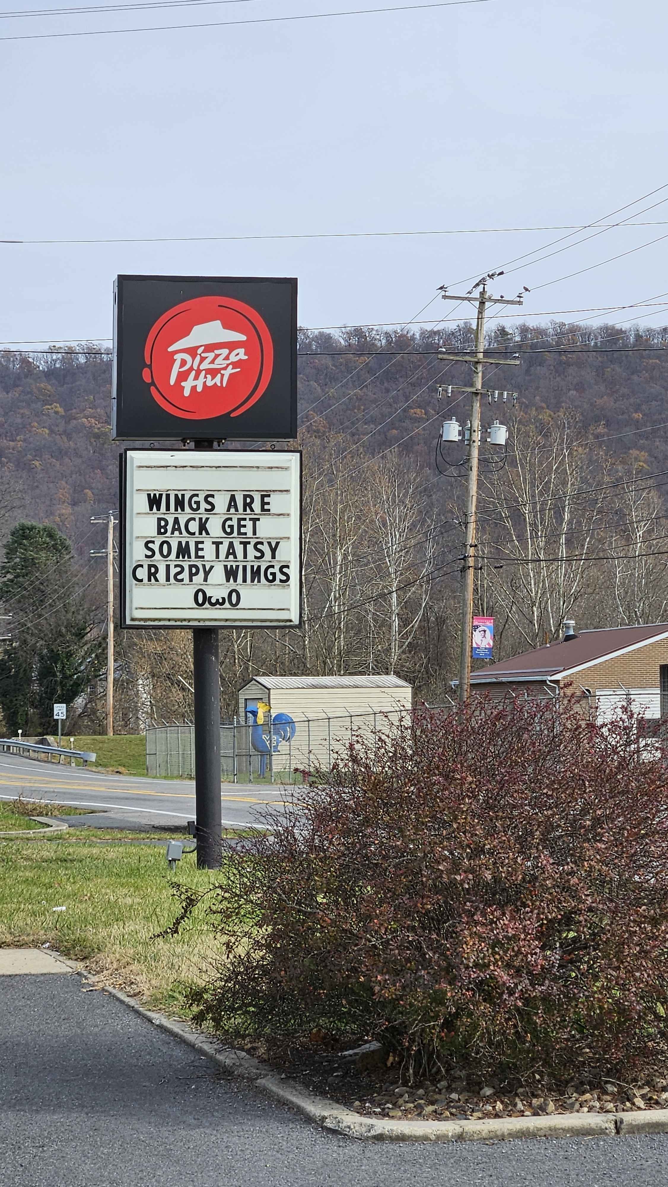
The filename alone gave me something to work with: 20241117_132821, so November 17th, 2024. That's a real timestamp, not a red herring, and it set a hard upper bound on when the photo was taken.
reading the image
I started pulling environmental signals before touching any tools. First pass:
- The ridge in the background is long, rounded, and parallel to the road. That's a classic Appalachian Ridge and Valley signature, not the Smokies, not the Blue Ridge proper. Think western Virginia, West Virginia, or central Pennsylvania.
- The shrubs in the foreground are red-leafed with a distinctive branching pattern. Japanese barberry or red-leafed ninebark, both common in the eastern US, both consistent with that region.
- The trees on the ridge are in late-fall defoliation, which lines up perfectly with mid-November.
- There's a military-themed banner visible on the utility pole in the background. November 17th is six days after Veterans Day, and small towns in Appalachia absolutely leave those up for a week or more.
- The sign says wings are back. Pizza Hut launched wings nationwide on February 1st, 2024, so this location had to be post-February. The November timestamp fits.
The sign also says "TATSY" instead of "tasty" which is extremely charming and completely unhelpful for geolocation. Noted anyway.
The image was a bit soft at distance so I ran it through waifu2x to upscale and sharpen before looking at finer details. Good habit for any geo challenge where signage or background text matters.
narrowing it down
Ridge and Valley province narrowed my search area considerably. I had three real candidates: western Virginia, West Virginia, and central Pennsylvania. I went with Virginia first, mostly on instinct. Lucky guess!
From there it was straightforward Google Maps work. I searched for Pizza Hut locations in the Ridge and Valley region of Virginia and WV, cross-referencing the road curvature visible in the image and the ridge angle relative to the sign. This looked like a small town and especially with the road trip narrative, I moved away from the beaten path. The road curves gently to the left in the background, the ridge runs roughly northeast-southwest, and there's a speed limit sign just barely readable at 45 mph.
Petersburg, WV came up after a little searching as a match. Small town, sits right in the South Branch Potomac valley, ridge running exactly where it should, and the road layout matched. I confirmed the Pizza Hut on Google Street View and the geography lined up!
the answer
The location is 444 Virginia Ave, Petersburg, WV 26847.
ZIP code: 26847.
tools used
No fancy gear required. The solve was mostly about reading the physical environment correctly before touching anything. Once you're in the right region, maps does the rest.
Geo OSINT lives and dies on your ability to extract signal from background detail. The ridge shape, the vegetation, the banner, the timestamp, the road speed limit, all of it narrows the polygon before you open a single tab.
Questions or corrections? Find me at hello@nyxvia.com